Imray Chart A24


Imray Chart A24
Regular price
Checking stock...
Regular price
Checking stock...
Proud to be B-Corp
Our business meets the highest standards of verified social and environmental performance, public transparency and legal accountability to balance profit and purpose. In short, we care about people and the planet.
The feel-good place to buy books
- Free delivery in Ireland
- Supporting authors with AuthorSHARE
- 100% recyclable packaging
- Proud to be a B Corp – A Business for good
- Buy-back with Ziffit
Imray Chart A24 by Imray
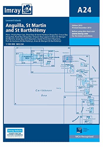
Plans included: Prickly Pear Cays (1:30,000) Shoal Bay & Island Harbour (Anguilla) (1:50,000) Crocus Bay (Anguilla) (1:15,000) Road Bay (Anguilla) (1:12,000) Simpson Bay Lagoon and Baie de Marigot (Saint Martin) (1:30,000) Great Bay (Sint Maartin) (1:15,000) Oyster Pond (Sint Maartin) (1:10,000) Port de Gustavia (Saint Barthelemy) (1:15,000) Anse de Marigot (Saint Barthelemy) (1:30,000) On this 2013 edition, details of the new cross-lagoon causeway bridge at Simpson Bay are shown, as well as associated depth and dredged channel changes. Harbour developments and the latest depths are also shown at Great Bay (Groot Baai) and Port de Gustavia. The remainder of the chart has been fully updated throughout.| SKU | Unavailable |
| ISBN 13 | 9781846235900 |
| ISBN 10 | 1846235901 |
| Title | Imray Chart A24 |
| Author | Imray |
| Condition | Unavailable |
| Publisher | Imray, Laurie, Norie & Wilson Ltd |
| Year published | 2013-12-01 |
| Number of pages | 1 |
| Cover note | Book picture is for illustrative purposes only, actual binding, cover or edition may vary. |
| Note | Unavailable |