Collins World Wall Laminated Map


Collins World Wall Laminated Map
Regular price
Checking stock...
Regular price
Checking stock...
Résumé
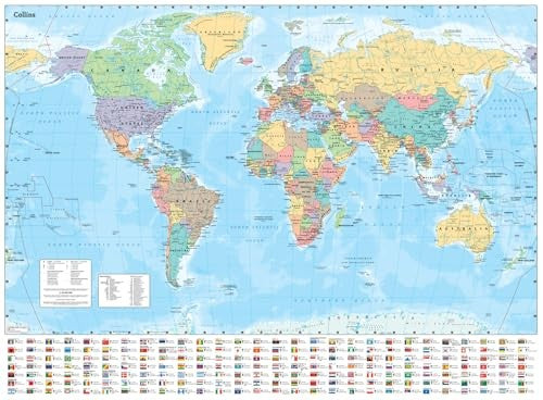
Explore the world with a Collins wall map
The feel-good place to buy books
- Free delivery in the UK
- Supporting authors with AuthorSHARE
- 100% recyclable packaging
- B Corp - kinder to people and planet
- Buy-back with World of Books - Sell Your Books
Collins World Wall Laminated Map by Collins Maps
Explore the world with a Collins wall map Fully updated world map to include the latest political changes. The map contains politically coloured mapping which shows each country and their capital city, major roads, and cities and towns clearly. Also included are national flags, key statistics for every country and inset maps of the polar regions. The map is printed on high quality paper and comes rolled in a fully recyclable cardboard box – ideal as a poster for any classroom, bedroom or office wall. Area of coverage: All of the world, centred on the Greenwich Meridian, and including maps of the North and South Pole regions. Scale: 1:30 000 000; 1 cm to 300 km; 1 inch to 480 miles Size: 700 x 915 mm (27.5 x 36 inches) Other versions available: Paper flat map (ISBN 978-0-00-849255-7)Explore the world through accurate and up-to-date mapping.
| SKU | Non disponible |
| ISBN 13 | 9780008712587 |
| Titre | Collins World Wall Laminated Map |
| Auteur | Collins Maps |
| État | Non disponible |
| Éditeur | HarperCollins Publishers |
| Année de publication | 2024-08-29 |
| Note de couverture | La photo du livre est présentée à titre d'illustration uniquement. La reliure, la couverture ou l'édition réelle peuvent varier. |
| Note | Non disponible |