


Lyngen Hiking Map by Calazo Forlag
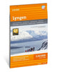
With map views on both the front and back, this map covers the entire Lyngen Peninsula with high, steep mountains and a typical alpine feel. Here are some of Norway's most popular areas for summit ski tours with classics such as the Jiehkkevarri traverse, Storgalten (1,219 m.a.s.l.) and Tafeltinden (1,395 m.a.s.l.). This is part of the modern map series from Calazo, with unique terrain information based on laser scanning from aircraft. This means that mountain slopes, waterways, glaciers and other natural elements are shown in much more detail than on previous maps.| SKU | Unavailable |
| ISBN 13 | |
| ISBN 10 | |
| Title | Lyngen Hiking Map |
| Author | Calazo Forlag |
| Series | |
| Condition | Unavailable |
| Binding Type | |
| Publisher | |
| Year published | |
| Number of pages | |
| Cover note | Book picture is for illustrative purposes only, actual binding, cover or edition may vary. |
| Note | Unavailable |
View All Editions
Filter
Applied Filters (0)
Sort by:
Loading editions...